Most proponents of the Jabal Maqla site believe that there is a location northwest of the mountain that corresponds to the story where Moses and the Israelites encamped at a place named Rephidim and a dramatic miracle occurred, followed by a battle with Amalekites who attacked the Israelites.
The Exodus Account
The last place where the Israelites encamp before reaching Mount Sinai is at a place called Rephidim (Exodus chapter 17).
Here, the population is desperate for water, causing great uproar against Moses. The Israelites complain, “Why did you bring us up out of Egypt to make us and our children and livestock die of thirst?”
According to the Exodus story, God tells Moses to “go out in front of the people” with some of the elders of Israel. God says He will “stand there before you by the rock at Horeb.” The text seems to indicate that the rock is distinct and in front of wherever the Israelites are camping.
God tells Moses to strike “the rock in Horeb,” which causes streams of water to flow from the rock for the population to drink from. The Biblical account states elsewhere that this happens with a “tremble,” indicating seismic activity (Psalms 78:9-16). It also says that the rock was split and waters “gushed out” from that split (Isaiah 48:21).
It also more specifically indicates that the water came downwards from the rock (Psalm 78:16), indicating that the rock was elevated. It is also fair to suggest that the rock would be large enough and high enough for a significant portion of the population to see, rather than rely solely upon the eyewitness accounts of Moses and the elders.
The book of Psalms also mentions how this happened “in the wilderness,” referring to the isolated mountainous terrain that the Israelites go through on the Exodus trip to Mount Sinai.
Moses names this specific area within Rephidim as “Massa and Meribah.” The former means “testing” and the latter means “quarreling.”
Josephus' account of the split rock at Rephidim closely mirrors the older Scriptural accounts. He writes:
When Moses had received this command from God, he came to the people, who waited for him, and looked upon him, for they saw already that he was coming apace from his eminence. As soon as he was come, he told them that God would deliver them from their present distress, and had granted them an unexpected favor; and informed them, that a river should run for their sakes out of the rock. But they were amazed at that hearing, supposing they were of necessity to cut the rock in pieces, now they were distressed by their thirst and by their journey; while Moses only smiting the rock with his rod, opened a passage, and out of it burst water, and that in great abundance, and very clear. But they were astonished at this wonderful effect; and, as it were, quenched their thirst by the very sight of it.
After this miracle, the Amalekites attack some of the Israelites from the rear, where the weakest of the people are. The account does not specify the size of this attack.
Joshua then leads Israelite forces into battle with the Amalekites. Moses, Aaron and Hur watch the battle on a hill. When Moses’ arms are held in the air as if he is praising God, the Israelites win the battle. When his arms drop due to fatigue, the Israelites begin losing, so Aaron and Hur assist by holding up his arms until the battle is won and the Amalekites retreat.
In searching for this location near a possible candidate for Mount Sinai, one would ideally find a distinct split rock is large enough and elevated enough for it to be visible to a large population stationed nearby.
It is possible that the rock could not be found today, as it may have fallen or broken in such a way as to be indistinguishable. However, there is historical documentation that the Split Rock of Horeb was identifiable in the 1700s A.D.
In a published translation of Josephus’ works by William Whitson, the translator writes in a footnote:
This rock is there at this day, as the travelers agree; and must be the same that was there in the days of Moses, as being too large to be brought thither by our modern carriages.
This account indicates that the Split Rock was still identifiable in the 18th century and that Whitson knew the rock's exact location. The translator indicates that it is too big to have been moved or transported, so it is quite possible that this is an authentic account.
Based on other citations in his translation, Whitson appears to locate Mount Sinai at the traditional site at Mt. Catherine. However, the fact that he identified a particular location for the rock, and claimed that it was a large structure, indicates that this was not something that traveled with the Israelites during their 40 years of wanderings, as some less common traditions have claimed.
Other possible indications to look for would be flows of water from and around the rock. The area around where the water flowed should be shaped in such a way as to be accessible to the thirsty population.
In terms of location, it must be “at Horeb” along a walkable route to Mount Sinai/Horeb. It should be in a very dry location without water nearby and within a mountainous “wilderness.”
The correct spot should have a plain on one side for the Israelites encampment, preferably with evidence of a population settling there.
It should also have a potential battlefield near the possible encampment site where the Israelite and Amalekite forces could meet and clash. There must be at least one hill on the edge of the encampment site overlooking the suggested battlefield.
Some presuppositions regarding this site include the belief that there must be a natural water source nearby from which the Israelites could have drawn water. However, this does not necessarily have to be so. As Rabbi Alexander Hool notes in chapter four of his book Searching for Sinai: The Location of Revelation, if there were natural water supplies in the area, Moses would not have needed to strike the rock to bring water forth by a miracle.
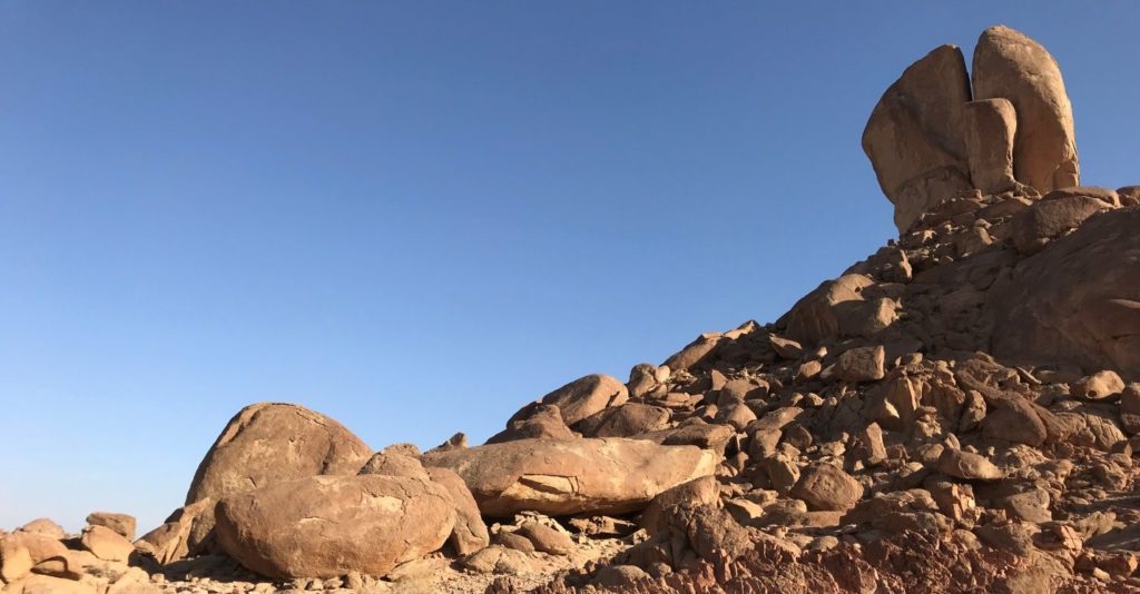
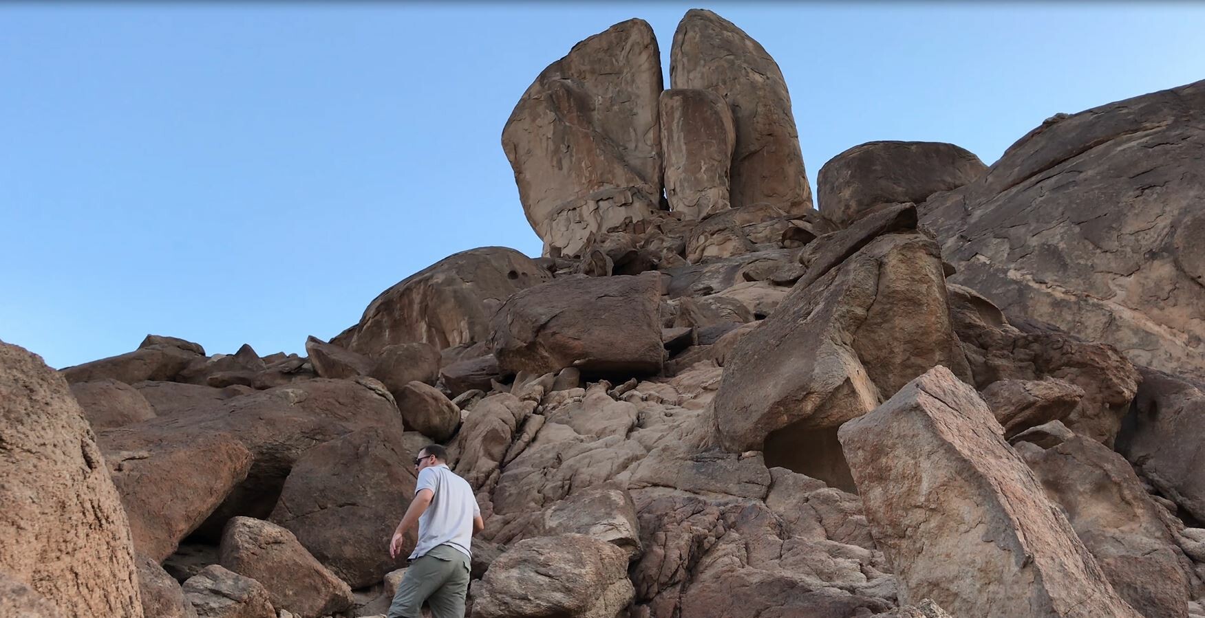
A Split Rock Near Jabal Maqla
There is a massive, visually-stunning split rock located northwest of Jabal Maqla along a possible route to the mountain. It stands approximately 50 feet tall on top of a hill that is approximately 100 feet high. The split in the middle is sizable enough for a person to stand inside of it.
It was found in modern times by Jim and Penny Caldwell, an American couple who lived in Saudi Arabia in the early 1990s.
The inside of the split is smooth and there appear to be smoothed paths downwards from the split. The ground level on both sides of the hill is smooth and uneven, giving the visual appearance of former water flows being there. It appears distinct from the rougher terrain that surrounds the site.
Yet, there is a lack of rainfall in this area of the world and there aren’t significant flash floods that could explain the apparent water erosion.
At the top of the hill, on one side of the split rock, is a large rectangular rock that may be holding the split rock upwards. In theory, this rectangular rock may serve a logistical purpose if the Exodus story is accurate. It would hold the split rock up for the scene to take place, as well as provide a safe spot for Moses to stand after striking the rock.
The Caldwell’s were told by local Saudi Bedouins that it was known as “Moses’ Water.” Others who have visited the area have been more explicitly told that it is the “Split Rock of Moses.” When asked about the source of that name, the Bedouin said it’s been called that for generations.
Some visitors to the site have reported being told by local Bedouins that it is a forbidden military zone closed to outsiders. Bedouins have claimed that they are ordered by the Saudi police to escort outsiders away and/or bring them to a local police station.
Criticism of the Split Rock Theory
Dr. Glen Fritz, who has a Ph.D. in Environmental Geography, is a supporter of Jabal Maqla’s candidacy as Mount Sinai but disagrees with the identification of this split rock with the “rock of Horeb” and Rephidim.
Fritz originally looked at satellite photos and suggested that there was “clear evidence of very high-pressure hydraulic erosion at the base and all around the lower portion of the rock.” He speculated that an underground aquifer could have stored the water and that the seismic activity described in the Exodus story could allow an artesian flow to rush to the surface.[1]
He has changed his position since visiting the site. Fritz’s primary objection is that he believes the location is not compatible with the route to Jabal Maqla that the Israelites would have taken based on the Biblical itinerary and topography.
He believes the split rock is a geological formation known as a hoodoo, a rock structure with a “totem-pole”-type shape due to weathering processes like wind patterns.[2]
However, our review of hoodoos has not yet yielded one that appears similar to the split rock. Rather, they are column-like. This formation appears to be a huge rock on top of a hill with a smooth split down the middle. The erosion is within this split, along several paths descending from the base of the rock, and in the front and back of the hill at the bottom.
The National Park Service says that hoodoos are caused by two weathering processes: Frost wedging and acidic rainwater that dissolves the limestone. [3] Running water can also cause the erosion necessary for a hoodoo to form.[4]
Both require a plentiful amount of rainfall that is not known to happen in this area. Furthermore, the labeling of the site as a hoodoo does not preclude it from being formed by sudden water flow.
Jehovah-Nissi Altar
The book of Exodus reports that the Amalekites launched an unprovoked attack on the Israelites from the rear, preying upon the weakest and most tired of the travelers.
Moses then orders Joshua to take the Israelites’ fighting men to the battlefield to face the Amalekites. Moses, Aaron and Hur climb atop a hill that overlooks the battlefield.
When Moses’ arms are raised upwards, resembling the praising of God, the Israelites have the edge in the battle. When they tire and fall, the Amalekites begin winning. Aaron and Hur help hold up Moses’ arms until the Amalekites are defeated. The lesson to the Israelites is that their accomplishments, including battlefield victories, are ultimately attributable to God and not their own might.
Moses constructs an altar near the bottom of the hill named Jehovah-Nissi in honor of the miracle. The altar might have steps, as God’s forbiddance of altar steps did not yet take place.
There are two structures near the Split Rock and the plain that may have been a battlefield that could arguably be the remains of Jehovah-Nissi. However, few details are provided about the hill, aside from that it was on the edge of the battlefield and high enough for Moses, Aaron and Hur to watch the battle.
The first proposed candidate is below the hill that the Split Rock is on. The hill extends horizontally to the edge of the plain, making it a theoretical match if the adjacent plain is the battlefield.
The Caldwells point to a large C-shaped rock here that has possible remains of a platform or steps around it. They say that the rocks were more clearly assembled as steps in the early 1990s and have since fallen.

Behind the C-shape (with the opening in the “c” facing the Split Rock), there is an elevated rectangular-shaped rock. It appears purposely placed.

On-site observation of this rectangular-rock showed it appears to be similar to another rectangular rock on an elevated platform in front of the possible stand for the Golden Calf. The book of Exodus states that there was an altar in front of the Golden Calf. This similarly-looking, potential altar-related rock at the likely Golden Calf worship site can be seen below:


The second structure that has been suggested to be Jehovah-Nissi is a few hundred feet away from the Split Rock in the adjacent plain.
It is a man-made structure that is 20-25 feet long and 3-4 feet high.
The Caldwells do not believe it is Jehovah Nissi because it closely resembles Ottoman-style structures they’ve seen while traveling elsewhere.
The Rephidim Encampment On the Way to Mount Sinai
The identifying of this location as Rephidim, the final encampment before the Israelites reach Mount Sinai, would help make sense of a confusing section in the Exodus story.
Chapter 17 says that Moses struck “the rock at Horeb,” but it says they are not yet at Horeb/Sinai (the terms are used basically interchangeably).
How can Moses strike “the rock at Horeb” if Rephidim is the final encampment before Horeb/Sinai?
If this is the location of Rephidim and Jabal Maqla is Mount Sinai, then the Israelites would have been on the west side of the mountain range, heading in a northeastern direction to come around and settle on the eastern side of the mountain.
Therefore, Moses would have been at the Rephidim encampment and struck “the rock at Horeb” while not yet being at the destination point on the eastern side of Mount Horeb/Sinai. Alternatively, one could interpret the description to mean that Horeb is describing a broader area (perhaps Jabal al-Lawz) that includes Mount Sinai (Jabal Maqla).
Amalekite Battlefield
The Split Rock location has a plain on either side, allowing for a theoretical Israelite encampment on one side and a battlefield for fighting the Amalekites on the other side.
The identification of this spot as Rephidim aligns with what little is known about the Amalekites.
However, Dr. Lennart Möller writes in Exodus Case, the Amalekites were an Arabian people, the oldest tribe of Arabia and the founders of the city of Medina.[5] The Encyclopedia Brittanica states, “The district over which they [the Amalekites] ranged was south of Judah and probably extended into northern Arabia.”[6] The Jewish Encyclopedia likewise states that the Amalekites were in northern Arabia.[7]
The Jewish historian Josephus identifies the Amalekites as people from the cities of Gobolitis and Petra. According to the Bible Atlas, Gobolitis was an area southeast of the Dead Sea, and a central location the alliance made between Moab, Ammon, and Amalek against Israel.
The ancient city of Petra, which remains a tourist attraction to this day, was in what is now southern Jordan.
The Exodus story does not require researchers to necessarily find evidence that the Amalekites controlled this specific part of northwestern Arabia.
The book of Exodus does not necessarily indicate that the Israelites entered Amalekite territory. Rather, it gives the impression that a group of Amalekites were traveling outside of their own territory, came across the Israelite population, and chose to attack them from the rear so they could victimize the weakest and most tired Israelites.
This does not necessitate an Israelite entry into Amalekite territory, but merely an encounter. It is possible that the Amalekite forces were probing nearby areas in order to identify resources and potential revivals. The size of the battle is not indicated, only that Joshua assembled “some of the men.”
The Caldwells say that they have found sling-stones in the possible battlefield area. Dr. Möller also noted in chapter 62.4 of The Exodus Case that he found small round stones around the area weighing between 0.2 kg and 0.5 kg.
Thamudic inscriptions have been found near the Split Rock. Dr. Miles Jones, a historical linguist, and scholar of Hebrew and the history of the alphabet, believes that this confirms the presence of ancient Israelites and refers to the clashes with Amalekites.
How Could The Israelites Fight The Amalekites?
An obvious question that one may have is how the Israelites could have fought the Amalekites if they just came from a life of slavery in Egypt. The Bible records that these former slaves had taken a wealth of valuable items from Egypt on their way out (Exodus 12:35-36), but there is no Biblical mention of armor or weapons with which they could have fought the Amalekites.
However, Jewish historian Josephus noted in Book II, chapter 16 of the Antiquities of the Jews that after Pharaoh's army was destroyed in the Red Sea, Moses ordered the Israelites to pick up the armor and weapons from the dead Egyptians whose bodies washed on the shore.
On the next day [after the parting of the Red Sea] Moses gathered together the weapons of the Egyptians, which were brought to the camp of the Hebrews by the current of the sea, and the force of the winds resisting it; and he conjectured that this also happened by Divine Providence, that so they might not be destitute of weapons. So when he had ordered the Hebrews to arm themselves with them, he led them to Mount Sinai, in order to offer sacrifice to God, and to render oblations for the salvation of the multitude, as he was charged to do beforehand.
Later, in Book III, chapter 1, he also wrote about how Moses reminded the Israelites as they complained that God provided for them all along the way, from protection during the plagues, to being provided with plenty of weapons when they had none.
After the battle, the Israelites gained even more weapons and armor as well, as Josephus wrote in Book III, chapter 2.
On the next day, Moses stripped the dead bodies of their enemies, and gathered together the armor of those that were fled, and gave rewards to such as had signalized themselves in the action; and highly commended Joshua, their general, who was attested to by all the army, on account of the great actions he had done. ... Moreover, he refreshed the army with feasting. And thus did they fight this first battle with those that ventured to oppose them, after they were gone out of Egypt. But when Moses had celebrated this festival for the victory, he permitted the Hebrews to rest for a few days, and then he brought them out after the fight, in order of battle; for they had now many soldiers in light armor.
These weapons and armor would come in useful years later as Joshua led the 12 tribes in conquering the Promised Land.
Proto-Hebrew Inscriptions
Inscriptions on rocks near the Split Rock site can still be found. Multiple were photographed by the Doubting Thomas Research Foundation in 2018.
Dr. Miles Jones reviewed pictures of the inscriptions originally found by the Caldwells. Many of them had a sandal, which the Caldwells suspected was the Israelites’ way of marking their territory.
When Dr. Jones looked at the sandal inscriptions, he noticed they were accompanied with Thamudic writing dating back to the 15th century B.C., the time period that most researchers believe to be the time of the Exodus story.
Furthermore, Dr. Jones believed the writing was ancient proto-Hebrew, indicating that the authors were the Israelites.
Dr. Jones’ book, The Writing of God, makes a Biblical case that God established a “literacy covenant” at Mount Sinai where mankind’s language advanced from pictographs to letters. He argues that the modern alphabet can trace its origins to the Jabal Maqla area.
Dr. Jones’ analysis of several proto-Hebrew inscriptions near Jabal Maqla (not the Split Rock) is that they are telling the story of an attack by the Amalekites.
Two inscriptions mark the spot where an Israelite mother and daughter died named Hagar and Amiah, daughter of Hagar.
A third inscription reads “Died Amalek,” marking where an Amalekite died, perhaps the same one who murdered the mother and daughter.
However, another expert in ancient Hebrew inscriptions, Todd Eaton, interpreted the “Died Amalek” inscription to mark the spot where a high priest died.
Possible Evidence of Encampment
There are structures that need further evaluating to determine if they could possibly have a connection to the Exodus story.
On the plain in front of the Split Rock, there are a series of large stone circles. They have been there since at least the early 1990s.
On the west side of the possible Rephidim location, there are many stone circles and possible burial cairns.
It has been speculated that the stone circles may have been for setting up large camps or other forms of temporary dwellings for people or animals. However, since there has long been Bedouin activity in this region, these circles could have been made by those nomadic tribes over the centuries.
Another Rock?
In his 1926 book The Northern Hegaz: A Topographical Index, Alois Musil stated that there is a large rock near the city of Al-Bad that he claimed was the spot where Moses struck and water gushed forth.
At first glance, one may think that Musil was referring to the large rock northwest of Jabal Maqla, but his description does not fit the geography of this particular spot.
Haggi Halfa, Gihan numa' (Constantinople 1145 A.H.) p. 525, describes Madjan [Midian] as a ruined town on the shore, situated six days' march to the west of Tabuk. Not far away the people exhibited a rock from which water gushed forth at the command of Moses. Many etel and mukl trees grew there, together with date palms. In the valley there were ruined walls and also stone slabs, upon which were cut the names of various kings.
The statement about the rock from which the water gushed forth at the command of Moses is of late origin, for in the earlier centuries this rock had been exhibited near Petra. The boulder in question is situated to the west of the burial place, but no water flows from it or near it.
Alois Musil, The Northern Hegaz: A Topographical Itinerary (New York: American Geographical Society, 1926), 281.
Musil's description does not fit the topography of what we believe is the rock from which Moses brought water. This rock is in a very dry place with little vegetation or trees. Indeed, hardly anything grows in this particular spot.
As of the time of this update, we do not believe Musil's site is the true site of the rock. However, the Doubting Thomas Research Foundation is willing to conduct further investigation into this site to see if there may be credible evidence.
To make this happen, we rely upon our donors to help us cover the costs of international travel and paying our staff for their hard work.
Please consider making a donation to help us continue the work!
Gallery


Bibliography
[1] Glen A. Fritz, The Lost Sea of the Exodus: A Modern Geographical Analysis, 2nd ed. (GeoTech, 2016).
[2] “Hoodoos.” National Park Service. https://www.nps.gov/brca/learn/nature/hoodoos.htm
[3] Ibid.
[4] Skorucak, Anton. What Are Hoodoos? ScienceIQ.com. http://www.scienceiq.com/facts/whatarehoodoos.cfm
[5] Lennart Möller, The Exodus Case, 4th ed. (Copenhagen, Denmark: Scandinavia Pub. House, 2010),278.
[6] “Amalekite.” Encyclopedia Brittanica. https://www.britannica.com/topic/Amalekites
[7] W. Max Muller, Kaufmann Kohler. Amalek, Amalekites. Jewish Encyclopedia. http://www.jewishencyclopedia.com/articles/1351-amalek-amalekites
Last updated June 24, 2019.
Pingback: Jethro and Moses in Midian - Jabal Maqla
Pingback: A Big Step Forward To Protect Mount Sinai - Jabal Maqla
Pingback: Timeline: The Tradition of Mount Sinai's Arabian Location - Jabal Maqla
I would really appreciate it if you could provide a fairly large scale map of the route they would have taken between this rock and the camp ground at Jabal Maqla, please.
Check out our maps page, where we have several potential routes along which the Israelites may have traveled.
http://jabalmaqla.com/maps-journey-sites-sinai/
Thank you.
Pingback: Proto-Hebrew Inscriptions Mount Sinai - Jabal Maqla